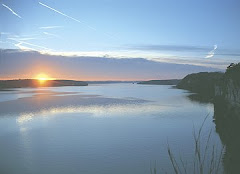
 The shimmering Lake of the Ozarks in Central Missouri is a major attraction for those who enjoy boating, fishing, swimming and skiing. However, especially with the rise of eco-tourism, thousands of visitors come to the Lake of the Ozarks area to explore its many miles of hiking and biking trails.
Lake-area hiking and biking trails are primarily located in Lake of the Ozarks State Park and Ha Ha Tonka State Park. In some cases, hikers and bikers, as well as equestrians, share the same trail. But strolling or cycling, Lake of the Ozarks trails offer a different perspective of Ozarks ecology and natural beauty.
The Trails of Lake of the Ozarks State Park
With 11 trails ranging from one mile to 16.5 miles long, Missouri’s largest state park (17.441 acres) attracts hikers, from casual strollers to serious trekkers. Altogether the park has 37 miles of trails winding through a diversity of landscapes—from lush fens to fields of wildflowers to breathtaking bluff top panoramas. The best way to start a hike is to stop by the Trail Center on Highway 34 for information about the trails and their features. The Park Office also has trail guides available. All of the park’s trails are open to the public. Entrance signs identify each trailhead and intersections are marked with colored directional arrows.
Favorite trails include:
Woodland Trail. This moderate six-mile hiking trail that starts behind the Trail Center meanders through the Patterson Hollow Wild Area. Hikers will see diverse habitats including old homesteaders’ fields, dense oak and hickory forests, dry streambeds, spring-fed seeps, nearly barren ridge tops and lush ravines. The solitude of the wild area can provide an outstanding opportunity to observe nature.
Trail of Four Winds. Hikers, bicyclists and equestrians share this 16.5-mile trail that takes visitors through some of the most scenic and challenging landscapes in the park. The trail winds through forests, open grasslands and bottomland hardwoods, and takes visitors along the Lake and past an unusual rock formation. A wooden boardwalk for leads to an overlook that provides a panoramic view of the forested valley below.
Squaw's Revenge Trail. The two-mile trail, used by hikers and equestrians, takes hikers or horseback riders through forested hills to bluff tops above the Lake where visitors enjoy a breathtaking view of the Grand Glaize arm. This trail formerly was used as a Civil War supply road. A group of Confederate soldiers carrying supplies here fell to a nighttime Union ambush; they’re buried in a small family cemetery in the Glaize Valley, which hikers pass by. The yucca plants, not native to Missouri, indicate settlers were here in the past.
Fawn's Ridge Trail. Hikers enjoy this easy, two-mile wildlife road that winds along the side of a wooded ridge and circles a hilltop. It’s not unusual to see early-morning songbirds and, as the name suggest, white-tailed deer. The first half-mile of the trail is accessible to people with disabilities or families with small children in strollers.
Rocky Top Trail. The first loop of this moderate, three-mile figure-eight trail travels through the most diverse glade in the park and along savanna and dry woodland slopes, then back along a pretty Lake cove. The second loop includes an overlook on a towering bluff and a typical Osage River Hills ridge top.
Some shorter hikes in Lake of the Ozarks State Park include: Lazy Hollow Trail, a half-mile trail through a peaceful Ozark hollow; the half-mile Shady Ridge Trail that winds along the Lake shore; the Bluestem Knoll Trail, a moderate three-quarter-mile loop through native grasslands, providing a glimpse of Missouri’s past 200 years ago; Lake View Bend Trail, a one-and-a-half-mile trail along the base of steep cliffs that provides a wonderful water view and puts on a spectacular show of spring wildflowers; and the one-mile Coakley Hollow Trail, which takes hikers over a boardwalk to Coakley Hollow Fen, and past a natural glad, dam and mill site.
Before or after a hike, Lake of the Ozarks State Park offers visitors a wide range of activities, including swimming at two public beaches, camping, fishing, boating and caving.
The Trails of Ha Ha Tonka State Park
Hikers at 3,600-acre Ha Ha Tonka State Park near Camdenton will find 13 trails covering 16.5 miles and leading past beautiful bluffs, dark caves and a “castle” on a cliff—actually, the ruins of a stone mansion built by a wealthy Kansas City businessman in 1905 and destroyed by a fire a year later. The one-quarter-mile Castle Bluff Trail takes hikers to the ruins and offers a view of Ha Ha Tonka Spring and the Lake from the 250-foot bluff. Eleven other trails, from one-half to seven miles, offer 16 miles of diverse hiking, from accessible, paved walkways to rugged, rocky pathways. A Trail and Natural Area Guide is available at the Visitor's Center at the park entrance. Some of the more popular trails include:
Quarry Trail. This moderate two-mile trail starts at the castle and takes hikers past panoramic Lake views and two old quarries.
Dell Rim Trail. Although it’s just one-half mile long, this trail features a wooden boardwalk and descends a series of steps to an overlook above the Whispering Dell Sinkhole, and down to the spring.
Colosseum Trail. This one-half-mile trail winds under the park’s famed Natural Bridge formation and through the Colosseum sinkhole—just two of the park’s amazing examples of karst topography.
Spring Trail. Hikers have a love-hate relationship with this one-and-a-half-mile trail. It travels through some of the park’s most breathtaking scenery—and includes a strenuous 316-step, 200-foot ascent to the bluff above the spring.
Island Trail. Hikers enjoy the rugged three-quarter-mile loop to the unique Balanced Rock formation.
Boulder Ridge Trail. Pass through a unique landscape of large, lichen-covered boulders along a ridge on this moderate one-and-one-half-mile trail.
Acorn Trail. Pre-settlement savanna characterizes this three-quarter-mile trail featuring interpretive stops.
Devil’s Kitchen Trail. This rugged one-mile trail guides hikers past Devil’s Promenade (a horseshoe-shaped cliff), a sinkhole and other unique geologic features.
Turkey Pen Hollow Trail. A rugged seven-mile trail winds through the scenic Oak Woodland Natural Area.
Dolomite Rock Trail. Visitors can pick up a brochure about this new half-mile trail that winds along a stream and ascends to a large hilltop glade.
Oak Woodland Trail. A short accessible trail with four interpretive stops.
Cycling at Lake of the Ozarks
“The Lake of the Ozarks area is increasingly becoming a cycling destination,” says Nicole Dougan, who, with her husband, Dan, owns the Lake-area’s mountain-biking headquarters, Oz Cycles at 1735 Bagnell Dam Blvd. In Lake Ozark. “The reason is our three trails that appeal to cyclists of all ages, styles and levels.” These singletrack trails range from six to 16.5 miles long, offering cycling excitement as well as exquisite scenery.
Trail of the Four Winds, located inside Lake of the Ozarks State Park, is the best-known trail in the area. Also a hiking and equestrian trail, it consists of loops that determine how far a cyclist travels, from three-and-a-half to 16 miles. The most popular route is an 11-mile loop with a one-mile climb at the end. The trail climbs through thick oak forests, travels along the Lake, runs over ridge tops and down into valleys. “It’s just a great trail, but not for beginners,” Dougan says. “Cyclists from Utah and Colorado come here just to ride this trail and it leaves them surprised and impressed.”
Honey Run Trail. Also located in Lake of the Ozarks State Park, Dougan notes this seven-mile trail is the only bike-specific trail in Missouri designated as such within the state park system. Built to meet the high standards of the International Mountain Biking Association, it consists of a pair of loops on easy terrain. “It’s a lot of fun, and fine for beginners,” she says. “More advanced cyclists also like it because although it doesn’t have a lot of stunts it does have some interesting technical areas.”
Bittersweet Trail. Located in the Lodge of Four Seasons area, this nine-and-a-half-mile, figure-eight trail was built and is maintained by mountain bikers. It crosses several creeks and offers a variety of stunts. “Beginners and families with children also enjoy the nice paved greenway starting at the Village of Four Seasons City Hall,” Dougan notes.
Information and trail maps are available at Oz Cycles, where visitors can rent bicycles and find out more about the weekly Phat Tire Hillbillies bicycle club ride every Tuesday evening. Visit www.oz-cycles.com or call (573) 964-7000.
And to find out more about hiking and biking, lodging and dining, shopping and events and more at the Lake of the Ozarks, please call the Lake of the Ozarks Convention & Visitors Bureau at (800) FUN-LAKE or visit www.funlake.com.

No comments:
Post a Comment